
Written by: Luca Grispiani
Site Locations Assessment
Site location Assessment is the first step in the design of any Offshore Wind Farm. The research for the most suitable marine area started from the “Draft Sectoral Marine Plan Offshore Wind Energy” (2019), issued by the Scottish Government. The following picture shows the current and planned offshore energy generation areas, where the team has selected three potential Marine Areas, and then assessed the characteristics.
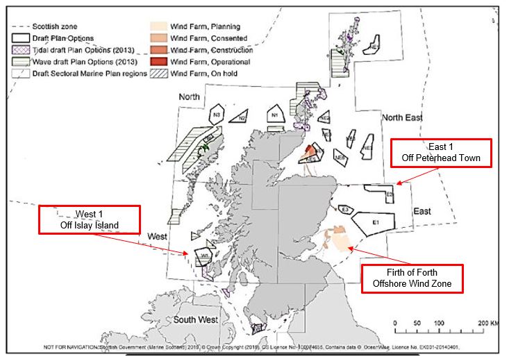
Figure: Current and planned offshore energy generation areas (Scot.gov, 2019).
The three marine areas are described in the following table:
Table: General Characteristics of Suitable Marine Areas to install the Offshore Wind Farm
| East 2 – Off Peterhead | West 1 – Off Islay Island | Firth of Forth Offshore Wind Zone |
| Mean Annual Wind Speed at 100 m a.s.l. is between 11.0 and 11.5 m/s | Mean Annual Wind Speed at 100 m a.s.l. is between 9.5 and 10.0 m/s | |
| The water depth is between 60 m and 100 m. Distance from shore is 50 km. | The majority of the marine area is in shallow water (< 60 m) with the exception of some small areas to the north-west. | Water depth is between 30 to 70 meters. |
| The SEIA might identify generally lower socio-economic costs arising from potential offshore wind development within the area. | The area is technically constrained with issues associated with the cities of Edinburgh and Dundee. The cities both have associated airports and harbours. | |
| Strong maturity of O&G Sector in the extraction of natural resources in the North Sea |
Therefore, based on the technical considerations shown on the table above, a Decision Matrix is built to select the most suitable area. A number of factors are considered: Wind Energy Resource, Distance from Coastal Facilities, O&G Sector Maturity, Water Depth, Maritime Commercial Activities. Each factor is briefly explained below. In the decision Matrix, a relative weighting and a scoring point from 1 to 3 are assigned to each factor in order to outcome with a total score to support the decision of the area. With regards to the score, 3 means the most suitable and 1 less suitable.
Wind Energy Resource
An important relative weighting of 25% is assigned to the Wind Energy Resource factor considering that more wind energy resource contributes to generating more power. Mean Annual Wind Speed Data shown in the table above has been acquired from the UK Renewables Atlas website. Therefore, a score of 3 is assigned to the West 1 Marine Area, and a score of 1 is assigned to Firth of Forth Offshore Wind Zone.
Water depth
Considering that the OFW will be composed of the Floating Offshore Wind Turbines, the most suitable water depth would be more than 60 meters depth. The relative weighting of this factor is 10%. Taking into account the water depth characteristics of the three marine areas, the most suitable water depth for a floating offshore wind turbine is the East 2 marine area.
Presence of Coastal Facilities
This factor accounts for the presence of Coastal Facilities suitable to receive the Hydrogen Gas Network. The relative weighting to this factor is 25%. Specifically, considering that the final product of Offshore Production is Hydrogen Gas, the team has given priority to look into the Costal Gas Terminals. The figure below shows that St Fergus Gas Terminal is the main Coastal Gas Termina in Scotland, hence it is a fundamental junction between the Offshore Extraction and the Onshore Consumption of Natural Gas. Therefore, it might be adopted to deliver the Hydrogen Gas from the Offshore Production.
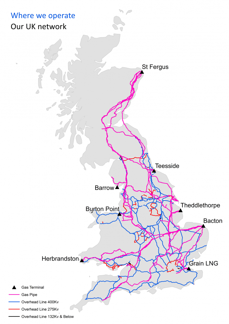
Figure: UK Gas Network Map (Nationalgridgas.com, 2019).
O&G Sector Maturity
Since the Oil & gas industry provided the basis for most of the initial expertise that currently applies to offshore platforms, the team has considered assigning a relative weighting equal to 20% for this factor. In particular, the score of 3 has been assigned to the Marine Area Easy 2, in consideration of the experience in the offshore extraction of natural resources in the North Sea.
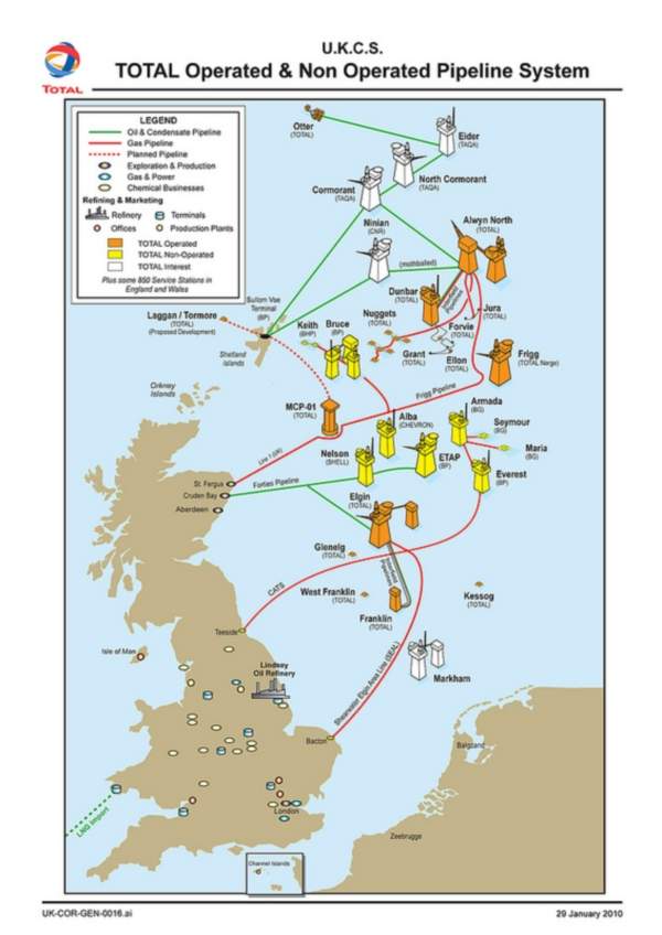
Figure: Simplified Distribution of Offshore Oil & Gas Platform in the North Sea (Total, 2010).
Maritime Commercial Activity
Maritime commercial activities are generally an obstacle to the deployment of an Offshore Wind Farm, in consideration of the potential interaction with dedicated lanes for navigation routes or with dedicated areas of higher fishing activity. Therefore, the following picture illustrates the density of maritime traffic around Scotland. It is possible to see that a higher density is present off the Eastern coast, which is supposedly less suitable to install a Wind Farm (score 1), while the maritime commercial traffic is more limited in the West 1 area (score 3).
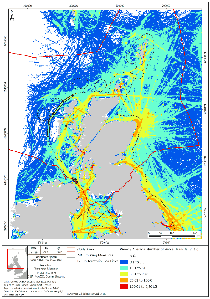
Figure: Maritime commercial Activities around Scotland (Scot.gov, 2018).
Thus, the table below shows the Decision Matrix to better evaluate the most suitable location.
Table: Decision Matrix to evaluate the most suitable location
| Factors | Relative Weighting | West 1 Off Islay Island | East 2 Off Peterhead | Firth of Forth Offshore Wind Zone |
||||
| Score | Total | Score | Total | Score | Total | |||
| 1 | Wind Energy Resource | 25% | 3 | 0,75 | 2 | 0,5 | 1 | 0,25 |
| 2 | Water Depth | 10% | 2 | 0,2 | 3 | 0,3 | 1 | 0,1 |
| 3 | Presence of Coastal Facilities | 20% | 1 | 0,2 | 3 | 0,6 | 2 | 0,4 |
| 4 | O&G Sector Maturity | 25% | 1 | 0,25 | 3 | 0,75 | 2 | 0,5 |
| 5 | Commercial shipping Activity | 20% | 3 | 0,6 | 2 | 0,4 | 1 | 0,2 |
| Total Score | \ | 2 | \ | 2,55 | \ | 1,45 | ||
As a result, the hypothetical wind park will be located in the area East 2 -Off Peterhead, characterised by a water depth of 100m approximately with a distance from shore of 50 km. The main factor that affected the final decision is the presence of coastal facilities. Indeed, in the vicinity of Peterhead Town is located the St Fergus Gas Terminal, where 40% of the Natural Gas is transported to shore from the North Sea Offshore Platforms through an extensive offshore pipeline network. Therefore, in this feasibility study of Offshore Hydrogen Production, St Fergus Gas Terminal might be adopted as a strategic junction from the offshore production and the onshore final consumption.
References
Draft Sectoral Marine Plan Offshore Wind Energy, Scotland Government, 2019, Scottish Government
Draft Plan for Offshore Wind Energy in Scottish Territorial Waters, Marine Scotland, 2010, Scottish Government
Spatial planning for sustainable marine renewable energy developments in Scotland, 2014, Scottish Government
Floating Offshore Wind Farms, 2016, L. Castro-Santos & V. Diaz-Casas, Green Energy and Technology, Springer
Multi-criteria Site selection for offshore renewable energy platforms, L. Cradden at others, Renewable Energy 87 (2016), 791 – 806
UK Atlas of Marine Renewable Energy https://www.renewables-atlas.info/