
 Home
Home 

| Mapping
|
'At a Glance' : Tides and
Gravity
|
Introduction
Many of the tidal stream assessments undertaken to date have identified a sizeable potential energy resource around the UK and notably, many are located in the West of Scotland. As investigations are on-going and accuracy and knowledge increase, it seems that each subsequent report builds on the knowledge gleaned in previous work in the field. One prevailing thread running through many of the reports consulted states that while a generic quantification of marine current resources can be presented, many of the idiosyncrasies associated with marine renewables deployment are highly site specific. In this vein, there may exist significant site specific error. As such, it was decided that it could be very beneficial for a potential developer to be able to assess the likely tidal current resource with basic tools, applicable to any given site.
Availability of Tidal Data
To date, efforts in the field of resource assessments have uncovered useful data on possible locations that would be suited to marine current generation, but a common observation is that the resolution of the data is more suited to rough site selection than focused energy extraction modelling. One particular resource for initial site selection is Atlas of UK Marine Renewable Energy Resources published by the DTi. This type of information is the result of numerous computer simulations and provide a variety of data about tidal currents. However due to the complicated nature of tidal interactions, the data analysis is said to break down at a close distance to land, and therefore the tidal developer must evaluate these areas closely when determining energy extraction potential.
There are other means of assessing tidal flow data, from areas such as hydrographic/admiralty charts and tidal atlases. Although this often means that calculations must be done by interpolating data from tidal diamonds to apply it to the particular site. Similarly, where tidal current velocities are given, they are often measured surface velocities, and in themselves may not allow the most accurate calculations, due to site specific conditions such as velocity profiles and bathymetry. For initial site selection purposes, it would also be fairly costly to purchase admiralty charts for a whole coastal region, so it is a good idea to undertake initial feasibility studies with information that is available in the public domain, and then focus efforts upon desired locations.
Carbon trust state: “The tidal stream resource is highly site specific”, thus intimating the potential for discrepancies in an overall resource characterization. There is therefore scope for the development of site specific methodologies and models.
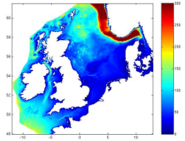
Figure from Atlas of UK Marine Renewable Energy Resources showing typical data on bathymetry
Relevant Research
1) ‘DTI (1992-1993) : UK Tidal Stream Energy Review. ’
- First official attempt to evaluate the UK’s tidal resources Identified a total of 25 sites in UK waters, with a combined annual output totalling some 58 TWh/yr
- Sites were collected into 7 main locations; 3 in Scotland; Pentland Firth & the Orkneys, West Coast, Galloway & Wigtown; 1 in N Ireland; the rest in England and the Channel Isles
- Report excludes sites where the depth of water is less than 20m, the output from these sites was considered to be less than 3% of the total resource
- Report concluded that although UK resource was large, the unit cost of energy would be relatively high
2)‘EC Joule II (1996) : The Exploitation Of Tidal /Marine Currents’
- EC Joule Programme Report identified a total of 42 sites with a combined annual output totalling some 31 TWh/yr.
- Report sites can be collected into the same 7 locations and 3 others (Shetland, Cornwall and the Menai Straits in Wales).
- At most locations the output is generally between 40% and 70% of that from the 1993 report.
- A number of such sites at depths of >20m are included in the report The West Coast of Scotland output is significantly increased by the inclusion of shallow water sites
3)‘DTI (2004): Atlas of UK Marine Renewable Energy Resources, Dec 2004’
- The aim was to present an accessible overview for the potential renewable energy resource in the UK, covers wind, wave and tidal predominantly
- Takes a significant step towards resource mapping and availability data.
- Fairly encompassing research, though the tidal resource model resolution is sufficient only for initial identification purposes, and would not help calculating potential energy yield to a high degree.
4) Carbon Trust
- The Carbon Trust is presently responsible for an initiative known as the Marine Energy Challenge.
- This programme has the aim to ‘assess the potential for marine energy devices to achieve a competitive cost of electricity generation against other renewables and fossil fuelled power generation’ (Carbon Trust, 2004).
- Part of this project is to assess the state of wave and tidal marine technologies and is working with eight technology developers to reach this.
- The Atlas project team has been in liaison with the Marine Energy Challenge to help improve the current understanding of technologies held within the Atlas database.
- For further information see the Carbon Trust website and follow links to the Marine Energy Challenge Newsletter
| Mapping
|
Go back to Contents