- Introduction
- Tidal Energy
- Resource
- Constraints
- Phasing
- Economic Analysis
- Conclusions
- Downloads
Policy Analysis
Policy Constraints
To get an idea of Scotland's realistic tidal resource it was essential to take into account policy factors that limit the unconstained resource. A policy constraint is any legislative rule that limits the deployment of tidal turbines at a specific site. Policy constraints have the provision to change in the future but have to be assessed on the situation as it is now. The table below shows examples of policy constraints that have to be taken into account when assessing the viability of a site for deploment of marine current turbines.
Shipping Lanes |
Areas of Military Activity |
Protected Wreck Sites |
Special Areas of Conservation |
Areas of Fishing Activity |
Sites Leased by the Crown Estate |
Marine Birds and Mammals |
Marine Recreational Areas |
Some of the information related to possible policy constraints is undefined and therefore will not be considered in this study. In particular there is little information on the possible impact of marine current turbines on marine birds and mammals and also no concrete information from the Royal Yachting Association (RYA) on their stance related to the deployment of marine current turbines in specific marine recreational areas.
Shipping Lanes
The first major policy constraint that was identified in this study was major shipping lanes. The density of traffic passing through a shipping lane is a good measurement of how constrained it is. For the purposes of this study only sites considered as being majorly constrained due to shipping lanes were considered. The following policy weighting was adapted from information given in the Scottish Government Marine Renewables Strategic Environmental Assessment .
Policy Weighting |
Shipping Concentration (Ships Per Day) |
Description |
Negligible |
0-0.5 |
No Effect on Vessels Navigation or Safety Issues |
Minor |
0.5-2 |
Short Term Displacement of Existing Vessels/Temporary Loss of Trade |
Moderate |
2-5 |
Long Term Displacement of Existing Vessels/Temporary Loss of Trad |
Major |
>5 |
Long Term Displacement of Existing Vessels Within a Constrained Channel or Entrance to Port/Long Term Loss of Trade |
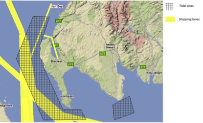
The ability to deploy tidal devices in a shipping lane is very much device specific and certain devices can installed in a manner where they will not cause any long term displacement of a shipping lane. It was found through this study that if a device could be installed 20m below the surface it would unlikely that it would affect cause the long term displacement of a shipping lane. The GIS image below shows majorly constrained shipping lanes off the coast of Dumfires and Galloway.
Areas of Military Activity
The waters around Scotland are used by the military for a range of activities including submarine and maritime exercises, bombing practice and diver training. A number of areas around the coast of Scotland have been marked as 'no-go' areas due the military activity on site and it is highly unlikely that planning permission would be granted for any kind of tidal development in these areas. In our analysis we used information of sites designated for military activites around Scotland from the Scottish Government Marine Renewables Strategic Environmental Assessment . The following polcy weighting was adapted when analysing the areas of military activity.
Policy Weighting |
Covers |
Description |
Negligible |
Unconstained Area |
Area is not constrained by military operation or activity |
Minor |
Undefined Training Areas |
Temporary Disruption (During Construction) causing activities to be adapted or relocated |
Moderate |
Diver Training Sites |
Temporary Disruption causing activities to be adapted or relocated |
Major |
Bombing Ranges;Submarine Exercise and Noising Ranges; Live Amminition Ranges
|
Highly Constrained-Long Term Disruption to Military Activities which cannot be adapted or relocated |
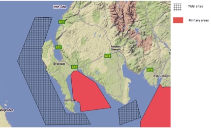
For the purposes of this study only military sites that were defined as moderate or major constraints were taken into account. The GIS image below shows the areas of military activity in a tidal area off the coast of Dumfries and Galloway .
Protected Wreck Sites
The seabed around Scotland is home to hundreds of wreck sites, the majority of these wreck sites are left unprotected and planning permission would likely be granted for tidal development at these sites provided excavation can take place. Some of the wrecks around the coast of Scotland at protected for historical reason and are often popular locations for diving activity. The data on the status of wreck sites was taken from a varierty of sources including Historic Scotland,Marine Scotland and the Scottish Government Marine Renewables Strategic Environmental Assessment. The following policy weighting was establish in order to analyse the effect of protected wrecks sites on Scotland's tidal power resource.
Policy Weighting |
Covers |
Description |
Negligible |
No Wreck at Site |
Activity at site unlikely to be affected by wrecks |
Minors |
Unprotected Wrecks at Site |
Activity at site unlikely to cause damage to unprotected wreck site |
Moderate |
Wrecks Under Consideration for Protection |
Moderately Constrained-activity at site likely to cause damage to wreck under consideration for protected status |
Major |
Protected Wrecks |
Highly Constrained-activity at site likely to cause damage to protected wreck |
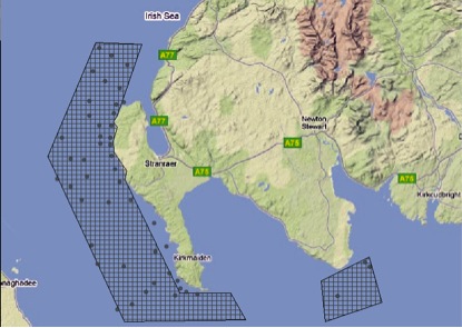
For the purposes of this study only wrecks sites that were defined as moderate or major constraints were considered. The GIS image below shows various wreck sites in a tidal area off the coast of Dumfries and Galloway.
Areas of Fishing Activity
Fishing in a major industry in Scotland with major ports situated all round the coast of Scotland. The analysis for fishing activites only considered areas that were clearly defined as having high levels of activity;these included localised fish farms and major fishing ports. The data for our analysis was compiled from a multitide of sources including Marine Scotland and the Scottish Government Marine Renewables Strategic Environmental Assessment reports. The following policy weighting was established in order to analyse the effect of fishing activities on Scotland's tidal power resource.
Policy Weighting |
Covers |
Description |
Negligible |
Fish Farms, Key Fishing Ports, Fishing Areas |
No impact on fishing activities |
Minors |
Fish Farms, Key Fishing Ports, Fishing Areas |
Causes Fleets to Temporarily Modify thier Shipping Activites and Total Number of Landings would not be reduced |
Moderate |
Fish Farms, Key Fishing Ports, Fishing Areas |
Reduces Access to Traditional Fishing Grounds/Causes Fleet to Modify their Shipping Activities/Total Number of Landings would not be reduced |
Major |
Fish Farms, Key Fishing Ports, Fishing Areas |
Long Term Reduction in Landings or Total Fishing Fleet |
For the purposes of this study only areas that were considered to have a moderate or major impact on fishing activities were considered. The GIS image below shows key fishing areas in a tidal area off the coast of Dumfries and Galloway.