Location
In order to study the feasibility of HOWaT, it was required to study if there was a suitable location for such a device. For the purpose of our project, we searched for a location in the UK which combined wind and tidal resources. In this page, the chosen location will be presented, as well as the methodology used to complete this task.
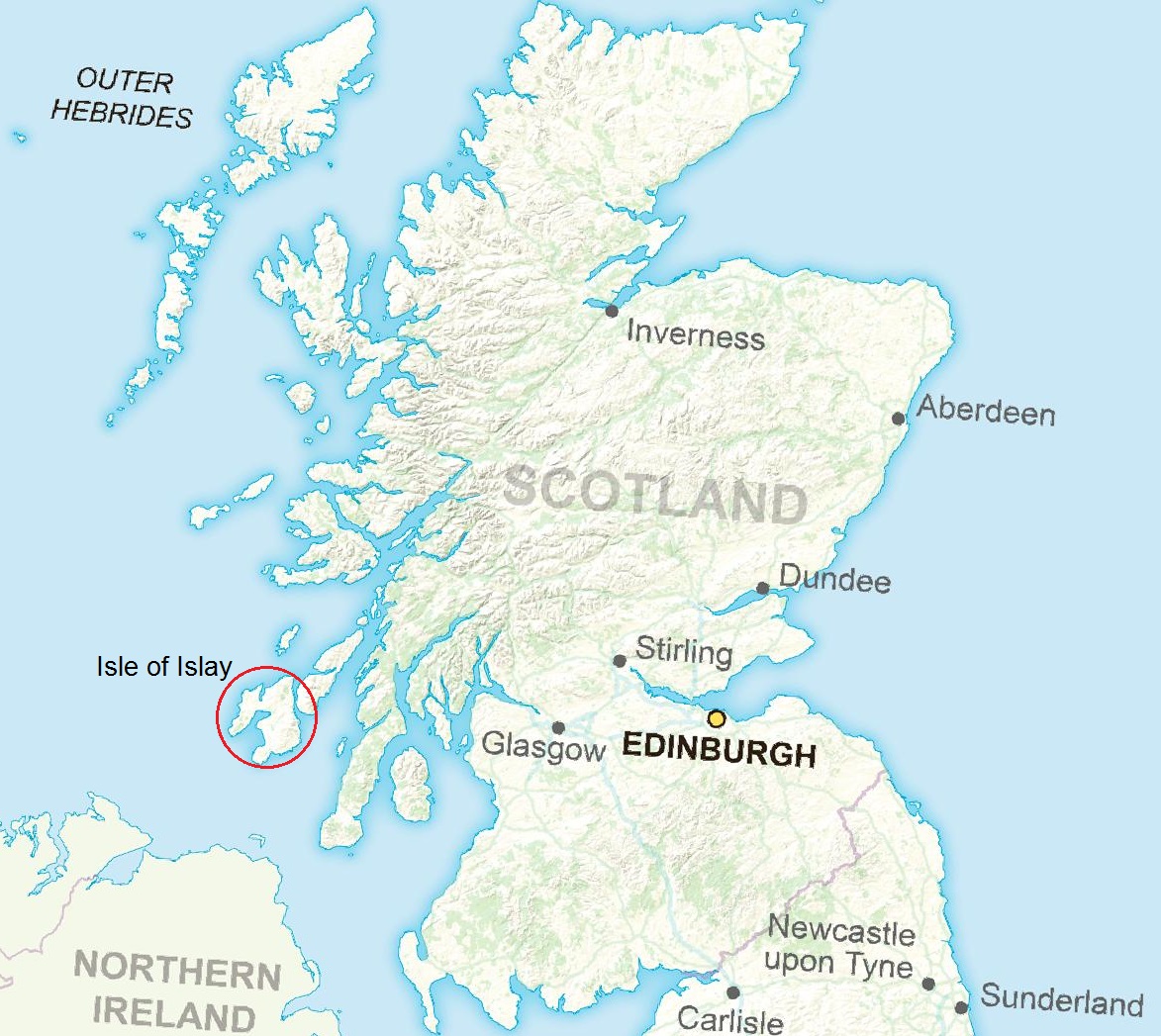
Chosen location: Isle of Islay
The location proposed to study the performance of our device is the Isle of Islay, on the West coast of Scotland. The sea to the West of the island has adequate wind and tidal resources at a depth which allows the use of monopile structures. In the following paragraphs, it will be defined what is an "adequate" resource and what other criteria have been used for the selection of this location.
Apart from the criteria that will be explained, it is remarkable that there where two real projects proposed at locations near the one that we have chosen. These two projects consisted on an offshore wind farm and a tidal energy generation farm. This fact represents another pillar in which we have based our choice.
It is important to remember that, even though we have developed our study for this particular location, the HOWaT could be applied to any location which meets the requirements that will be explained. It is true that finding a location with both tidal and wind resources is not easy. However, if such a location exists, it would probably be more interesting to install a hybrid device instead of a device which generates energy from only one source.
Preliminary steps: attaching tidal generators to existing wind farms
At a first stage, even before creating a conceptual design of the device, we considered the possibility of attaching tidal turbines to existing wind farms. In order to perform this analysis, we looked for british offshore wind farms maps [1], with the particularity that the farms should be relatively close to the shore in order to maximise the available tidal resource.
One of the most important sources of information was The Crown State, specifically one of their publications [2], which included maps of wave and tidal resources in the UK. From these maps, we could get information about tidal ranges and streams. The main map from this source is shown in Figure 2.
Tidal range is the height difference between high and low tide. High tidal ranges can be useful for electricity generation in installations like tidal barrages. However, due to the presence of wind generators in our project, it is more interesting to have several devices spread in an area instead of a linear array. For this reason, tidal power has to be extracted from streams instead of ranges.
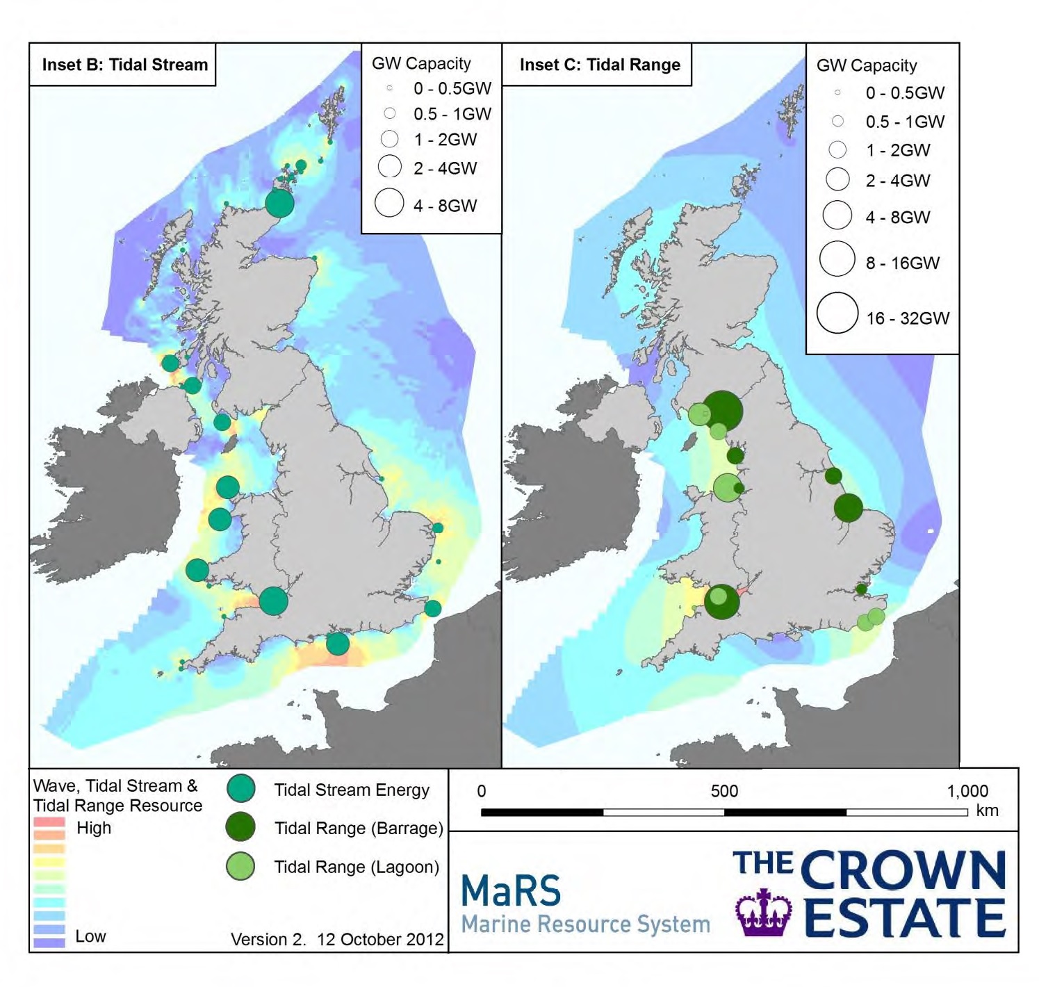
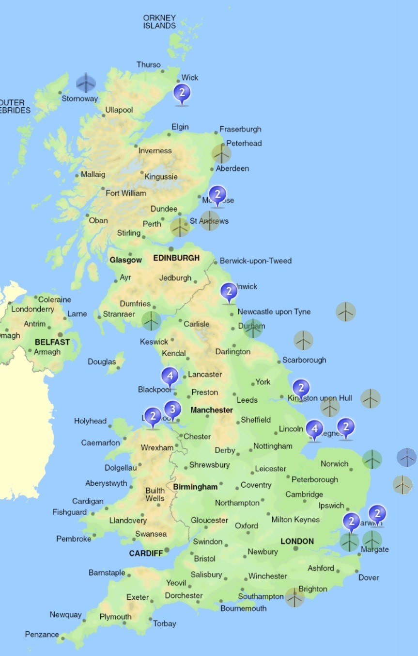
From the maps above, it can be seen that wind farms are generally not located in areas with specially high tidal streams. There are, however, three wind farms that resulted interesting during this analysis. These wind farms are Navitus Bay, Rampion and Scroby Sand. They are located in the Southeast of England, in areas close to potential high tidal streams, but not close enough for the resource to be significant. Therefore, the idea of attaching tidal devices to wind generators in existing offshore farms was discarded. The next research stage could begin.
Combining maps of wind and tidal resource
By this point, the search for a location could be based purely on the natural resources available. Wind energy has been deeply studied, so the most important problem was related to the tidal resource. As a preliminary approach, it was necessary to find out an acceptable range of values for depth below sea level and tidal stream velocity in order to generate energy in a economically viable manner. Another document from The Crown State [3] gives some reference values that we used. These values are:
- Depth below sea level: greater than 5 m
- Tidal streams: greater than 1.5 m/s
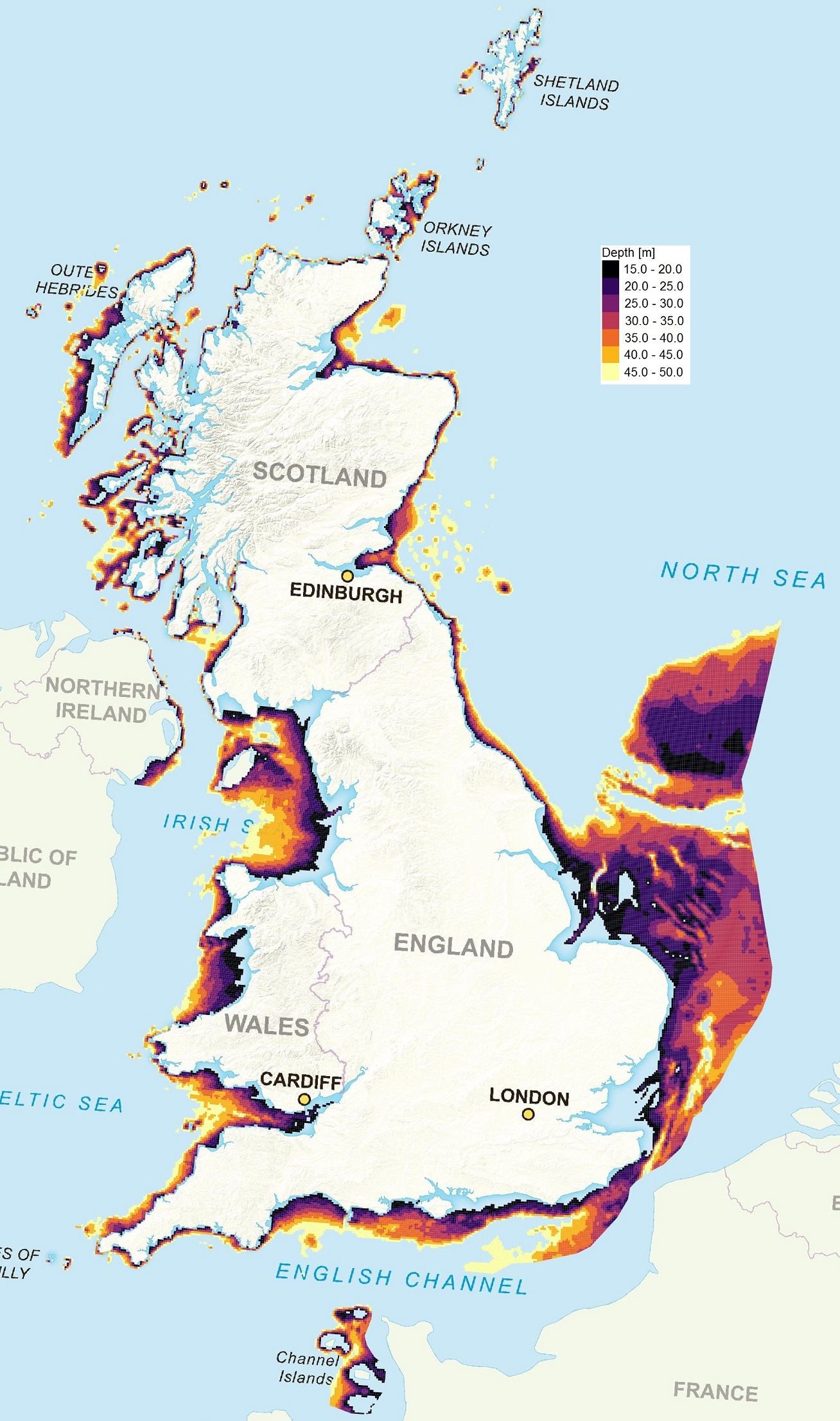
Regarding depth below sea level, the document has a comment in which it is explained that different sources consider 15 m as the minimum depth for an economically viable tidal stream generation. Therefore, we have used the latter value rather than 5 m. With regards to the maximum depth, the limitation comes from the monopile for the wind turbine. This kind of support structure is used for depths up to 30~50 m [4], [5]. We chose then to search for locations in the range from 15 to 50 m, and then analyse the natural resources available on them.
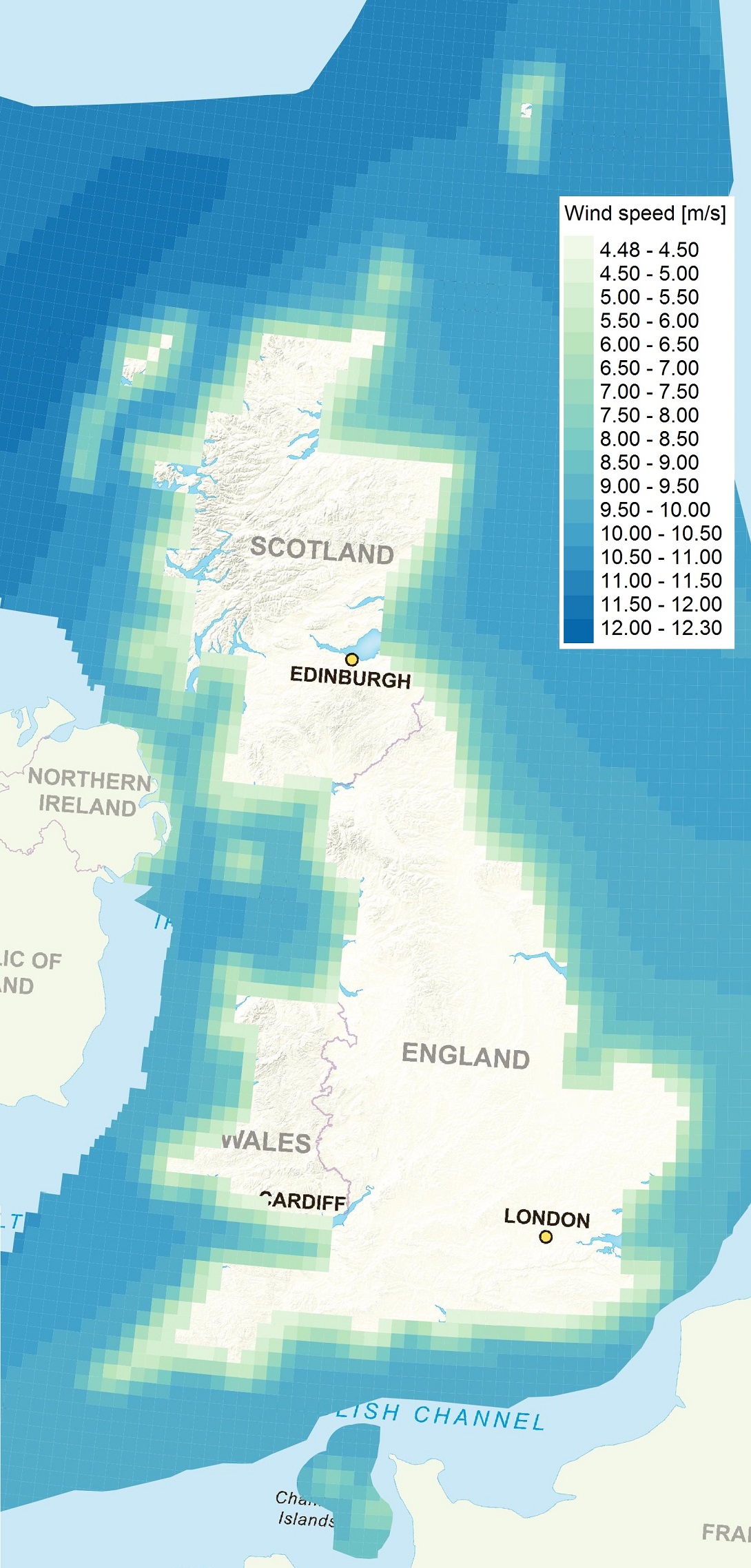
This investigation was done using a Geographic Information System (GIS). A GIS is a kind of program in which the user can obtain and represent information based on its geographic position. For example, we used maps created by the Atlas of UK Marine Renewable Energy Resources [6] which have information about the tidal and offshore wind resources. Thanks to the use of GIS, the results could be filtered depending on the depth or the maximum tidal stream speed amongst other properties. The software used to use these maps was QGIS, a free and open source GIS.
Choosing a location UK-wide
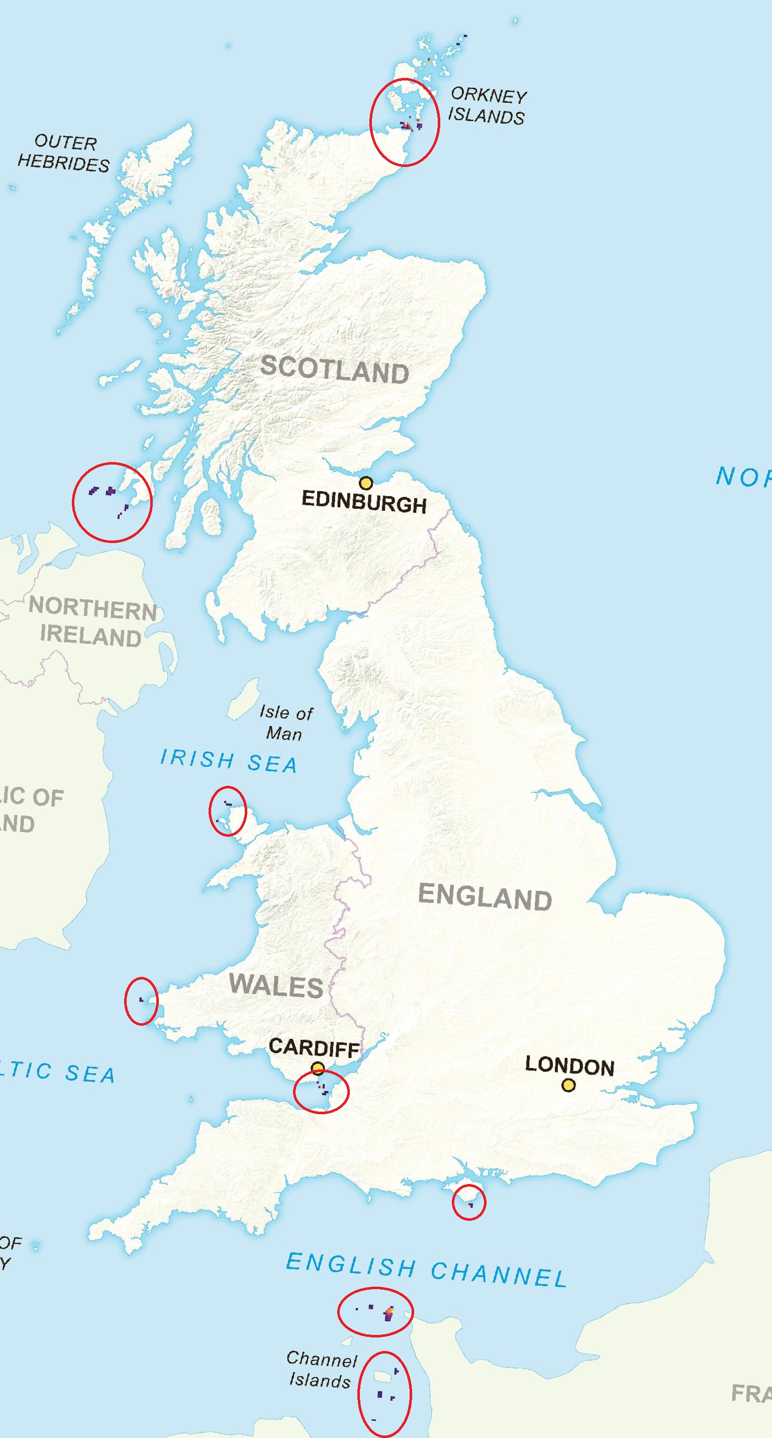
After obtaining the map presented in Figure 6, we had eight locations to choose from. During this stage we found out that some places, like the one close to Cardiff, are more appropriate for tidal lagoons rather than stream turbines. Moreover, the environmental impacts are significant in places like the Orkney Islands. Considering the maritime traffic, the spots around the Channel Islands were discarded.
From the remaining options, the one with the greater area of potential tidal resource was the Isle of Islay. We also discovered that there were two existing projects to build an offshore wind farm in the surroundings of this location [7], as well as a tidal farm [8]. Finally, the decision had been taken.
Choosing a location in the Isle of Islay
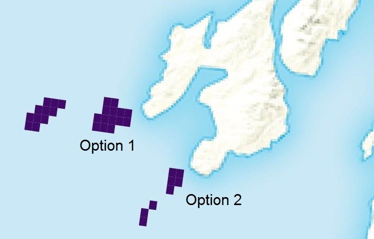
As already stated, the Isle of Islay offered an important area of adequate tidal and wind resources. This was good, but it meant that we had to choose with even more detail. We had mainly two options:
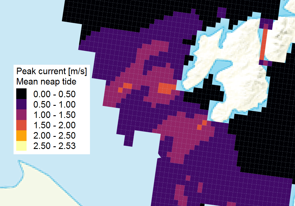
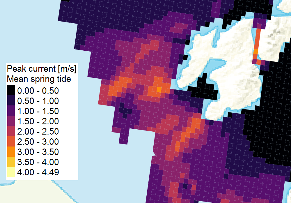
In both sites, the depth was very similar, 28 to 30 m. What made the difference in this case was the distance to the coast, together with the peak current velocities for neap and spring tides. The most western option offered higher speeds, and also was further from the coast. This is important with regards to visual impact, as discussed in the scoping report that can be found in the EIA page. The visual impact of tidal farms is negligible, but in the case of offshore wind farms, it is important. The western location is 8 km away from the coast, while the other is much closer. This way, tidal resource and distance to the coast indicate what is the best location, that finally was chosen.
Conclusion and following steps
The chosen location offers one of the highest tidal stream resources in the UK, and at the same time, an adequate wind resource. It is not easy to find a location where both resources are high, which represents a drawback of our proposal. However, if a location is found, our proposal can be very advantageous.
Once the location was chosen, one of the first steps of the research was done. There were different analyses ahead of us, which would be supported on the one described in the paragraphs above. It is worth to mention that, even though the proposed hybrid device is intended to be used in any adequate location, performing this research in a specific spot was very helpful in order to obtain some results that otherwise would have been based only on assumptions or would have been quite vague. Although it can be argued that choosing a location can subtract generality to the project, it allows to perform an in-depth investigation on different aspects.
- http://renewables-map.co.uk/
- The Crown State (2012). UK Wave and Tidal Key Resource Areas Project. Summary report. Available online
- The Crown State (2013). UK Wave and Tidal Key Resource Areas Project. Technical methodology report. Available online
- 4coffshore.com (2013). Monopiles support structures. Available online
- Sarkar, A. (2013). Offshore wind turbines supported by monopiles. PhD thesis. University of Stavanger
- Atlas of UK Marine Renewable Energy Resources (2008). ABPmer. Date of access: 02 February 2017. http://www.renewables-atlas.info/
- Islay Offshore Wind Farm Proposal (2010). SSE Renewables. Available online
- West Islay Tidal Energy Farm. DP Energy website. Last accessed 4 May 2017.