Small Scale Hydro: Novel Approaches to Generation & Transmission
LowFlows - An Overview
Introduction:
LowFlows (Version 1.0 Commercial) is a software application used for the calculation of water flows from specific catchment areas. It was originally developed by the Centre for Ecology and Hydrology, but is now maintained and developed by Wallingford Hydrosolutions. Where measured data is not available, LowFlows allows for the calculation of natural flow statistics and also lets the user add any artificial influences that may or may not already exist so as to understand their impact on the catchment area. The software is recognised by the Scottish Environmental Protection Agency and the Environment Agency in their respective roles of maintaining areas of natural interest across the United Kingdom. In the instance of natural water flow, there are strict guidelines in place to ensure minimal impact of any diversion/re-distribution of water for power generation and as such Low Flows is the recommended application for ensuring water flows are maintained at the required levels.
Method:
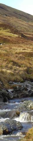
In order for the relevant data to be produced by LowFlows, the rainfall catchment area for a given hydro intake needs to be defined. On a site visit to Glen Almond, in conjunction with the ground works contractors, intake sites were identified and with the use of a handheld GPS unit, approximate altitude readings taken. We used this data to plot the intake locations on 1:25000 scale Ordinance Survey maps. The highest points surrounding the intake locations, where gradients were in the direction of the intake, were identified and their co-ordinates noted. The joining of these co-ordinates with straight lines results in a catchment area polygon being created, as shown in the image to the right. The catchment area polygon co-ordinates were converted to the full 8 digit national grid co-ordinate system, before being saved as a .CSV file, and imported into LowFlows. An example of a .CSV file is available here. Once the .CSV file was imported to LowFlows, the region of the country in which the catchment area is situated was selected. It was now possible for both annual and monthly flow duration curves for each catchment area to be calculated.
Conclusions:
The data provided by LowsFlows is in the form of monthly and annual exceedance curves and is used to ascertain the 95% exceedance flow. This is the flow of water which will be exceeded 95% of the month/year and the annual exceednce flow is flow required by SEPA to remain in a watercourse. An example of the data produced can be seen here in the attached Excel spreadsheet file.
The resulting data was used in both the small scale hydro calculator to help size the turbines of interest in our case study site and also in providing the initial flow characteristics for the CFD analysis for the transmission of power through a non-pressurised supply tunnel.
Discussion:
In considering how LowFlows data is produced, we decided to look at and compare the results with readliy available Met Office rainfall data from two nearby weather stations. LowFlows uses rain fall data from sites across the country from the period 1960 to 1990. When comparing this period with more recent rainfall data from the last 20 years, there are some concerns that the version of LowFlows we are using underestimates rainfall today. However LowFlows does take into account ground composition and evaporation, factors we could not as easily take into account.