|
|
|
|
| What
is SRTM?
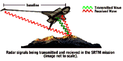
The Shuttle Radar Topography Mission (SRTM) was a joint project between the National Aeronautics and Space Administration (NASA) and the National Geospatial-Intelligence Agency (NGA). This project was carrying out in 2000 with the aim of producing digital topographic data for all land areas comprised between 60º North and 56º South latitude which is equivalent, approximately, to 80 % of the Earth’s land surface and with data points located every 1 arc second on a latitude/longitude grid. SRTM used the radar interferometry as a technique to obtain the data. Radar images were taken from different locations and their differences (between these images) were used for obtaining the surface elevation.
The SRTM data was subjected to several steps of processing and as a result different types of data are available. It was processed at Jet Propulsion Laboratory (JPL) in California and sent to NGA for its final finishing. These files are supplied in different formats and with different “resolution” depending on the place referred by the data (United States or areas outside United States). SRTM data is distributed in two versions: Version 1: is the original digital elevation data . It is unedited and contains some areas of “missing” data. Version 2: is a superior version result of processing and editing of the National Geological Survey . Data are improved but they still contain some areas of missing data like spikes and wells. It is the second version we have employed in our project. SRTM DATA AVAILABILITY: As it has been mentioned before, data is delivered with different “resolutions”:
Each point, in case of using the averaging method, is the average of the nine one arc-second surrounding the point in question. This type is delivered by LP DAAC in a SRTM format and without
restriction. It covers the land surface from 56º North to South.
This sample is what has been employed in this project (ftp://e0srp01u.ecs.nasa.gov/srtm/).
When is delivered by Seamless Data Distribution System. SRTM data is also available on DVD delivered by Eros Data Center. We could then use this information to construct topographic maps of any part of the planet.
|