|
|
|
|
|
Wind Variations and Weibull distribution
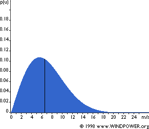
During the year, very strong winds are rare whereas moderate winds are quite common. The Weibull distribution is usually used to describe the wind variation on a site (see figure above). A Weibull distribution can be described by the mean wind speed and the shape parameter of the curve. This distribution is actually a probability density distribution. The area under the curve is then always equal to 1. Half of the blue area is to the left of the vertical black line at 6.6 m/s. this value is then called the median of the distribution, which means that half the time the wind speed will be less than 6.6 m/s, the other half the wind speed will be more than 6.6 m/s. The statistical distribution of wind speeds is different everywhere on the globe, depending on local climate conditions or the landscape and its surface. The Weibull distribution then varies, both in its shape and in its mean value. If the shape parameter is 2, as in the graph above, the distribution is known as a Rayleigh distribution, which is the most used by wind turbine manufacturers to give standard performances for their machines. The Wind Rose
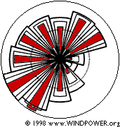
Wind rose from Brest, France, taken from the European Wind Atlas, Riso National Laboratory, Denmark. All around the planet, strong winds usually come from a particular direction. The wind rose allows to drawn on a same diagram the distribution of wind speeds and the frequency of each wind direction. A disc is usually divided into 12 sectors, one for each 30 degrees of the horizon (can also be divided in 8 or 16 sectors). The radius of the 12 wider wedges gives the relative frequency of each of the 12 wind directions. The second wedge also gives this information, but multiplied by the average wind speed in each direction, the result being then normalised to add up to 100 percent. This represents the contribution of each sector to the average wind speed on the site. Finally, the red wedge gives the same information than the first, but multiplied by the cube of the wind speed in each location. This indicates the contribution of each sector to the energy content of the wind on the site. This last indication is obviously the most important given by the wind rose to choose the best location for a turbine. Wind Rose Variations
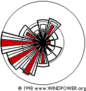
Wind rose from Caen, France, taken from the European Wind Atlas, Riso National Laboratory, Denmark. In the case of Brest, we can see that the prevailing wind direction is SW. But wind roses vary from one place to another. They actually are a form of meteorological fingerprint. If we take the wind rose of Caen (in France, only about 150 km NE from Brest), we can see that even if the prevailing wind direction is the same nearly all of the wind energy comes from West and SW, so we don't need to consider the other directions on this site. Even if wind roses from neighbouring areas are often quite similar and that a simple transfer of observations from a place to another close place is sometimes satisfactory, such an assumption can be dangerous in case of complex terrain, with mountains and valleys for example. A wind rose is very useful for the sitting of wind turbines. The wind rose indicates the relative distribution of wind directions. If a large proportion of the wind energy comes from a particular direction, it is important to find a site with no obstacles in this direction and a terrain as smooth as possible. Nevertheless, it is important to remember that the wind distribution can vary from one year to another, so it is best to have information from several years to make a reliable average. Usually, to establish this long term average, measurements are made directly on the potential site for one year, and log term meteorological data from a nearby weather station are used to adjust these measurements.
|