|
|
|
|
|
Direct Measurements
In order to measure the wind resource on a site, one or more
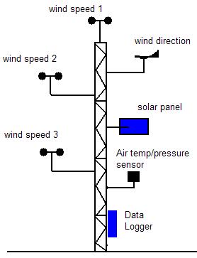
meterological measurement masts are erected. Generally, the mast height is chosen considering the hub height of the planned wind turbine. Wind speed must be measured at at least two different heights with anemometers (usually cup anemometers are used) and wind direction is determined with wind vanes. It is important to notice that a good calibration of the measuring instruments is essential.
Click here for a discription of meterological mast instruments The method to record the measurements is generally the same: quantities are recorded and stored in a data logger as 10 minute mean values, max and min values and standard deviation. Of course, to take into account seasonal variations of wind speed and direction, the minimum period of measurement must be 12 months. Monthly overview can then be provided, including:
These measurements over a period of at least a year can be considered as a reliable database for assessing the wind resource of the site. However, to take into account the annual and long term variations of the wind regime (over periods of ten or twenty years), these results must be correlated with long term data from a near meteorology station if available. Indeed, wind turbines having generally a lifetime of twenty years, these long term variations are important to assess the economic efficiency of the project. To achieve this correlation, it is essential to evaluate the comparability of the terrains of both sites. The quality of the data available must also be high. Ideally, the data available must cover a period of at least ten years and must come with the same format and resolution (10 minute mean values) as the actual measurements. Finally, it is important that the long term data covers the measurement period, this overlapping period giving a good idea of the quality and the accuracy of the data. Once this correlation has been made, a function can been found covering the whole long term period, giving that the level of accuracy between the measurements and the long term data is satisfactory. The long term wind resource can then be assessed at the measurement site. As we saw, the combination of these two methods is usually needed to obtain reliable estimation of the wind resource. Modelling tools are used to transfer measured wind data from a known site to another. The presence of meteorological stations in the area is very useful to estimate the wind resource on a long term period. The following method is generally used:
< Back | Next: However >
|