Single Issue Tools - Simple - Sun Charts
Design tools are required to assess site and building layouts for passive solar design. The resolution of such issues can be achieved from consideration of the angular relationship between the sun, the building and any shading devices and obstructing bodies. Such design tools are often manual methods. In the heating season the aim is to avoid overshadowing so that beneficial solar gain can be harnessed to offset the heating load. Sun charts can be used to assess the degree of shading on the building facades due to terrain features, surrounding buildings, facade projections and local landscape features. Dirrerent approaches exist to analyse the direct solar beam:
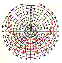
To assess the solar availability on a site, shading from adjacent buildings and vegetation must be determined. To represent the sun's position in the sky two Azimuthal (planar) projections are used: Stereographic and Gnomic.
The stereographic chart projects
a view of the sky onto a horizontal plane. Radiating lines indicate azimuth
and concentric circles show angular altitude. The chart can be likened to a
photograph where a 180 degree fish-eye lens has been used tophotograph
the sky looking straight up. The example to the right illustrates a chart for
52 degrees North.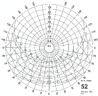 For
each latitude there is a specific stereographic diagram. These diagrams may
be used to indicate which sections of the sky are free of obstructions and,
consequently, the relative importance of the periods when solar light will be
blocked. The horizon is represented by the outermost circle, at the periphery.
The altitude of the sun above the horizon is read on the various concentric
circles, from 0 to 90 degrees. The angle of azimuth is written on the periphery
(0 degrees is south, east and west are 90 degrees on either side).
For
each latitude there is a specific stereographic diagram. These diagrams may
be used to indicate which sections of the sky are free of obstructions and,
consequently, the relative importance of the periods when solar light will be
blocked. The horizon is represented by the outermost circle, at the periphery.
The altitude of the sun above the horizon is read on the various concentric
circles, from 0 to 90 degrees. The angle of azimuth is written on the periphery
(0 degrees is south, east and west are 90 degrees on either side).
The various trajectories of the sun's movement in the sky are plotted, for the 21st day (equinox) of each month from December 21 until June 21. The other months are obtained using the following rule of equivalence: July-May; August-April; September-March; October-February; November-January. The other lines, perpendicular to the sun trajectories, provide a way to estimate the position of the sun for a given time, which is an approximation of the solar time.
It should be noted that the sterographic chart is only one of many graphical plots used to display solar geometry. The cylindrical solar chart is the primary means of assessing overshadowing as discussed in this example.
The variations in solar altitude and azimuth are the consequences of the daily rotation of the earth about its polar axis, and the annual movement of the earth about the sun. The earth follows an elliptical path, with the poles inclined at an angle of 23.45 degrees to the plane of the elipse traversed. The position of the sun may be predicted for any latitude, time of day, and any day of the year, using simple trigonometric formulae that works in solar time. The data from such calculations are used to contruct the various graphical aids such as the sterographic direct solar beam projection.
The Solar time at any place refers to the precise time of day when the sun crosses the north-south vertical plane. This moment is defined as solar noon. The sun reaches its greatest elevation at this time. For most circumstances it is adequate to work in solar time, which fully defines the geometry of the problem.
Methods for adjusting between local time and solar time in different time zones are explained in a number of texts, along with the detailed trigonometric calculation of the sun's position.
In order to use the various graphics tools, it is first necessary to understand the meaning of the angles used to describe the position of the sun.
Solar altitude and azimuth
The angular position of the sun as
seen from a particular place on the surface of the earth varies from hour to
hour and from season to season. The basic position of the sun at any instant
can be described by two angles: the
solar altitude (angle gamma) and azimuth (angle alpha). The
reference plane for the solar altitude is the horizontal plane. The altitude
is the angle between the line to the centre of the sun and the horizontal plane.
When the sun is on the horizon, the solar altitude is 0°; when directly
overhead 90°. The reference plane for the
solar azimuth is the vertical plane running north-south through the poles. The
azimuth is the angle between true south and the point on the horizon directly
below the sun. By convention, it is negative before noon and positive after
noon. The azimuth is referenced to due south in the Northern hemisphere. The
example to the right illustrates the sun angles for 56 degrees North latitude.
The reference plane for the
solar azimuth is the vertical plane running north-south through the poles. The
azimuth is the angle between true south and the point on the horizon directly
below the sun. By convention, it is negative before noon and positive after
noon. The azimuth is referenced to due south in the Northern hemisphere. The
example to the right illustrates the sun angles for 56 degrees North latitude.
At the northern hemisphere's summer solstice (21June), the sun's rays make an angle of 23° 27' to the equatorial plane. The beam is approximately perpendicular to the Tropic of Cancer (22° 30'N). In the northern hemisphere, the day length reaches its maximum value on this date. North of latitude 23° 27'N, the solar altitude at noon is at its greatest value for the year. At winter solstice (21 December), the sun's rays make an angle of -23° 27' to the equatorial plane. The beam radiation is approximately perpendicular to the Tropic of Capricorn (20°30'S). In the northern hemisphere, the days are at there shortest and the solar altitude at noon has its lowest values.
At the northern hemisphere spring and autuum equinoxes (21 March and 22 September), the sun's rays are perpendicular to the equator. The day and night lengths are almost equal everywhere in the world.
The solar altitude and azimuth over the year can be plotted on a solar chart. The altitude scale is shown on a series of concentric circles. The azimuth scale is set around the perimeter of the chart. The azimuth angle is read by setting a straight edge from the centre of the chart to the intersection of the required hour and date path lines and noting where it cuts the chart perimeter. Different charts are required for different latitudes.
In Southern Europe, at a latitude of 36°N, the sun's path is 240° wide at the summer solstice and the maximum solar altitude is 77°. At the winter solstice, the sun's path is 120° wide and the maximum solar altitude is 30°. In Northern Europe, at a latitude of 56°N, the sun's path is 270° wide at the summer solstice and the maximum solar altitude is 58°. At the winter solstice, the sun's path is 90° wide and the maximum solar altitude is 11°.
The detailed impacts of geometric layout and shading geometry can be analysed using sun position techniques on the basis of the availability of sunlight at specific times of day/year and at any facade location. A monthly schedule of the hours of sunshine availability can then be prepared. This provides the basis for any subsequent energy analysis.
Energy in Architecture - The European Passive Solar Handbook, CHapter on the prediction of solar geometry, Publication No. EUR 13446, Commission of the European Communities, 1992.