Route Planning
This page describes the process used to decide on a route and how this route will be represented in four waypoints for the rest of this study.
Choosing Southampton to New-York
A route from Southampton to New York was chosen because both are major industrial shipping ports. A study looking at Southampton to New-York would also act as an indication as to how Flettner Rotors could perform in similar routes such as between ports further down the East coast of the USA to Miami, or further up the continent to Halifax in Nova Scotia, similarly at the European end of the journey it could represent trips involving ports in Norway, Germany, and France. The Route was finally decided to be between Southampton and New York after extensive reading into publicly available published studies did not show any papers looking at that specific route. This allowed the project to add to the wide knowledge base already existing for Flettner Rotors.
How the Route was Mapped
The process of route planning in modern shipping is incredibly complicated, relying on expensive software to map a route involving great circle navigation, and weather data to find the optimal route. Weather routing systems have been developed to involve directing the ship in a way which would benefit Flettner Rotor operation and find the most desirable sea states on a journey. However, these studies are far beyond the scope of this project, so weather dependant routing will not be considered further, but is acknowledged as a vital component in the optimisation of the performance of Flettner Rotors.
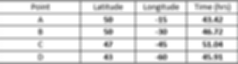
Great circle navigation is used by ships and aircraft, as simply the shortest distance between two points on the globe due to the curvature of the earth. A ship routing system would normally incorporate this great circle navigation and deviate from it depending on weather and sea state. Although this project will not map a route dependant on weather, it can use great circle navigation for its route. As great circle navigation gives a curved path, it is common practice for ships to split this curvature into several smaller straight journeys, as to not waste fuel constantly using a rudder. Although industry routes usually have hundreds of sections, our journey has been split into four sections to simplify our problem for the scope of this study. Sections are labelled A-D from the closest to UK being A and closest to New York being D. Splitting the journey up allows 4 individual waypoints to represent each journey, for which weather data can be sourced.
To map the route the longitude and latitude points were found using an online great circle navigation calculator for between Southampton and New York. The lat/long co-ordinates from the online calculator were imported into excel and then into Tableau software to allow overlay on to a picture of a map.
The initial great circle navigation can be seen to intersect with Nova Scotia so the route was mapped again with a way point forcing the route away from the land. Therefore the new route uses two great circle navigation paths instead of one to better represent the shipping route. The journey close to each port has also not been considered due to the assumed altering ship speeds, direction, and unclear use of Flettner Rotors as the ship approaches the port. Hence, this study will only consider the open water operation of the ship. The combined great circle navigation points as well as they’re segregation is shown.
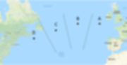
The Final Route
The way points for the final route that this project will consider are shown below on both a map and in a table, along with the time taken for each section of the journey, given a constant ship speed of 13.3kn (speed explained in the Maxsurf study).
With simplifying the journey as we have, it was then possible to extend our research to cover every month of a year. Therefore, the project will consider this route at the start of each month of 2018, both from UK to USA and back again over the same period of days to give a rounded view of yearly operation for a Flettner Rotor across the North Atlantic.