|
|
|
|
Summary
The NASA/NIMA (now NGA) Shuttle Radar Topography Mission (SRTM) collected interferometric
radar data which has been used by JPL to generate a near-global topography data product for
latitudes smaller than 60.
As part of the SRTM mission, an extensive global ground campaign was conducted by NIMA/NGA and NASA to collect ground-truth which would allow for the global
validation of this unique data set. This report presents a detailed description of how the results in
this table were obtained. It also presents detailed characterization of the different components of
the error, their magnitudes, and spatial structure.
The performance requirements for the SRTM data products are:
- The linear vertical absolute height error shall be less than 16 m for 90% of the data.
- The linear vertical relative height error shall be less than 10 m for 90% of the data.
- The circular absolute geolocation error shall be less than 20 m for 90% of the data.
- The circular relative geolocation error shall be less than 15 m for 90% of the data.
The table shown below summarizes the SRTM performance observed by comparing against the
available ground-truth. All quantities represent 90% errors in meters. It is clear from this table that
SRTM met and exceeded its performance requirements.
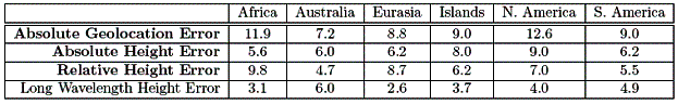
We have found that the SRTM error could be divided into very long wavelength (continental
scale or larger) errors and short wavelength random errors. To show the relative magnitude of the
two contributions, the table also lists the magnitude of the long wavelength error (which contributes
to the absolute vertical accuracy).
The ground truth data collected were not appropriate for validating relative geolocation errors. It
is expected that the main sources of geolocation errors are also long wavelength, so that the relative
geolocation error will in general be smaller than the absolute geolocation error, since common errors
will cancel. The absolute geolocation performance is better than that required for the relative
geolocation, which provides indirect evidence that the relative geolocation requirement was also
met.
SRTM Error Sources
Errors After Static and Dynamic Calibration
Interferometric errors can be divided into static and time-varying errors. Static errors are those
which can be regarded as having been constant over the data collection. Since these errors are
constant, they can be calibrated by means of natural or man-made targets with know position and
height. Time varying errors are due to motion of the interferometric mast and changes in the beam
steering. These errors can be partially compensated by dynamic calibration and
mosaicking.
We list below the main contributors to the static and dynamic errors, the calibration method
used to estimate them, and the magnitude of the residual error after calibration.
-
Baseline Roll Errors: An error in knowledge of the baseline roll angle will induce a cross-track
slope error in the estimated topography whose magnitude is equal to the roll error. The
SRTM instrument used a sophisticated metrology system (AODA) coupled with post-flight
filtering and estimation of the baseline position. The main components of the baseline motion
are due to the natural modes of oscillation of the mast. These motions can be modeled and
removed so that they do not constitute a dominant error source. In addition, the baseline
position is affected by the Shuttle’s attitude maneuvers. The time scale for residual roll errors
is long, resulting in spatial errors with wavelength on the order of thousands of kilometers.They constitute the primary source for long-wavelength residual errors. Figure 1.2 shows a
representative example of this residual long-wavelength error estimated by subtracting the
sea surface topography, which is know to centimetric accuracy from the SRTM estimated
topography. The peak values of this residual error are ±10 m.
-
Phase Errors: These errors are due to two sources: thermal or differential speckle noise and systematic
phase changes due to antenna pattern mismatches or long term drift of the instrument
electronics. The noise contamination result in height errors which are random and which exhibit
short spatial correlation lengths. These errors cannot be compensated during ground
processing.
The antenna patterns for each of the channels do not have identical far-field phase characteristics.
If uncompensated, this phase mismatch causes results in a net systematic phase error
(called the phase screen) which is a function of the look angle. Due to the stability of the
antenna far-field phase, this phase screen can be estimated by binning the height errors over
the ocean as a function of look angle and applying the mean phase bias as a function of angle
as a phase correction to the interferogram.
To estimate this phase screen, SRTM collected data prior and after each continental crossing,
as well as for a small number of basin-wide ocean data takes. Estimates of the phase screen
were obtained as a function of time and for each of the four SRTM elevation beams and all
beam positions. The phase screen correction was not observed to change significantly over the
mission lifetime: the estimated changes in the height error correction were estimated to be
below 10 cm.
Finally, a slow drift of the differential phase was observed over the lifetime of the mission (see
Figure 1.3), probably due to slow changes in instrument temperature. The residual phase
errors induce cross-track tilts which are practically indistinguishable from the residual roll
errors discussed above.
- Beam Differential Errors: Systematic phase differences between the SRTM beams induce height
differences at the beam overlaps. These difference can be time-varying since the beam steering
angles are changed according to the topography to preserve the swath. This dynamic effect is
corrected during ground processing by using the beam overlap height differences to estimate
beam phase offsets. Since the instrument was designed so that all beams overlapped continuously,
a time varying along-track phase calibration could be estimated and applied to the data.
This ensured that all beams had a consistent phase error. The residual error due to this phase
mismatch was negligible (below 10 cm) after along-track calibration.
-
Timing and Position Errors: These are induced by uncompensated delays in the system or errors
in the estimated baseline position and result in geolocation errors. These errors are calibrated
by using targets whose position was known and which could be identified in the radar image or
topography, such as corner reflectors or kinematic GPS transects. The calibration procedure
is as discussed in in great detail in Section 5.1. The residual geolocation errors are discussed
in Section 5.2.
Absolute Height Error Conclusions
For all of the data sets examined, the SRTM data meets and exceeds the performance criteria, often
by a factor of 2. There is a broad agreement between all the ground-truth data sources, but the
largest deviations are exhibited by the height patches and some of the DTED 2 patches and land
GCPs. Given the overall consistency in the mean error shown by the SRTM data, it is possible that
the mean shifts between the data sets are not due to SRTM.
Reference:
An Assessment of the SRTM Topographic Products
E. Rodriguez, C.S. Morris, J.E. Belz, E.C. Chapin, J.M. Martin, W. Daffer, S. Hensley
|
|
|