 |
|
 |
|
Greek islands have all the characteristics of the so called “remote areas”. Today there are more than 30 islands of different size in Greece that are not grid connected and possess small autonomous grids. Those grids are usually powered from diesel generators which are neither the cleaner nor the most efficient generators. Diesel has also to be transferred on site, and this poses other problems. In the winter months communication is sometimes difficult to be established due to bad weather. In addition the cost of transporting diesel to the islands is quite high and this means that the cost of producing electricity is also high. People in the islands actually buy the electricity cheaper than it is produced (since there is a common price for the whole country). The cost of producing electricity in the islands is 5 times higher than that of producing it in the mainland. In the recent years some RES have been integrated to the small island grids but without –most of the times- exploiting a great deal of the RE potential available.
The RE potential of those islands is quite high, one of the highest in the country as it can also be seen in the CRES website. It is also well known that even in the ancient years people were exploiting this potential by using numerous windmills. The idea of the case study was driven by the aforementioned characteristics together with the vision of a pure hydrogen economy, where hydrogen would be generated from RES.
The islands chosen for the study are the Karpathos-Kasos complex and Crete.
![]()
Crete is the biggest Greek Island and its located in the south part of Greece.. The island's main information and energy characteristics are shown in the the following table.
|
General Information |
|
|
Population |
537,00 |
|
Area (Km2) |
8,335 |
|
Anual Demands |
|
|
Electricity Demand (TWh) |
1.92 |
|
Transportation (GWh) |
333 |
|
Heating (TWh) |
2.62 |
|
Energy System Charachteristic |
|
|
Installed Power (MW) |
694,3 |
|
Maximum Recorder Power (MW) |
407.2 |

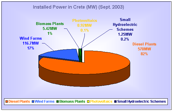
According to the ministry of Development the Electricity is produced from the following sources. As it is shown the 99% is being produced from 2 Diesel Plants in Chania (Ksilokamara) and Heraklio (Linoperamata) and Wind farms that are located to the east part of the island especially to Lasithi and Agio Nikolao.
![]()
Those 2 islands are situated in the SE part of Greece very close to Rhodes. They operate on their own autonomous grid that consists of a diesel generator and a small wind farm situated in the northern part of Karpathos. Demographic and energy data of the Karpathos-Kasos complex can be seen summarised at the table below. A map of the islands is also shown.
|
General Information |
|
|
Population |
7200 |
|
Area (Km2) |
367 |
|
Anual Demands |
|
|
Electricity Demand (GWh) |
24.37 |
|
Transportation (MWh) |
1.315 |
|
Heating (GWh) |
31.78 |
|
Energy System Charachteristic |
|
|
Installed Power (MW) |
9 |
|
Maximum Recorder Power (MW) |
6.5 |
The 2 islands are interconnected with underwater sea cables, and blackout problems have been recorded especially in Kasos due to damage of those cables either from fishermen or from natural phenomena (last incident 25-28 July 2003). The wind potential map provided by CRES suggests that there is enough wind potential for building wind farms in the island complex. Furthermore, due to the problems mentioned above we thought that at least one of the wind farms should be placed on Kasos ensuring this way a certain energy security supply.

References:
[1] Hellenic Regulatory Authority for Energy