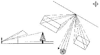
 describe
the position of a surface relative to the sun and are important in passive solar
design.
describe
the position of a surface relative to the sun and are important in passive solar
design.
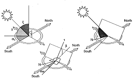
The diagram to the right illustrates
solar altitude, solar azimuth, angle of incidence, surface tilt and wall azimuth.
The various angles describe
the position of a surface relative to the sun and are important in passive solar
design.
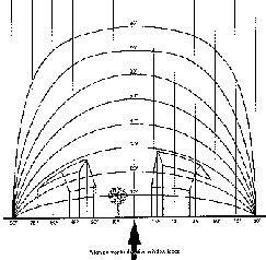
Cylindrical solar altitude and azimuth graphs
The data obtained by calculation can be plotted in a number of different ways. While horizontal sun dial type (stereographic) charts give an overview of the solar geometry for a particular location, other types of graphical plot are more effective for assessing overshadowing. One useful plot is the vertical cylindrical solar altitude and solar azimuth chart. The altitude of the sun is plotted against the solar azimuth for specific days. The cylindrical plots can be cut along the north solar azimuth and laid flat. It should be noted that this is not the projection used in design plans and elevations. The cylindrical chart has to be interpreted for orthogonal design purposes.
A Graphical chart of the solar altitude
plotted against solar azimuth (latitude 44°N) for various dates
in the year is shown to the right. The
 hour
lines, in solar time, run up the chart, crossing the sun path line for the various
dates. It should be noted that the charts cover a sector of 120°E
to 120°W, which is only part of the full 360° cylinder. The truncation
was done to produce more compact charts. However, as a consequence, the movements
of the midsummer sun around sunrise and sunset lie off the charts at higher
latitudes. One of the dangers
of this projection is that it is often interpreted, erroneously, as covering
only 90° each way from the south. The northward solar penetration
can thus get overlooked. Obstruction
data can be plotted on the chart, but this must be done using the obstructing
altitude appropriate to each wall solar azimuth angle. The angles cannot be
directly read from drawings Interpretative difficulties often arise because
the plot of the roofline of a parallel obstructing building is a curved shape
on the projection. The plotting of parallel obstructions can be aided using
an auxiliary overlay aid as explained later.
hour
lines, in solar time, run up the chart, crossing the sun path line for the various
dates. It should be noted that the charts cover a sector of 120°E
to 120°W, which is only part of the full 360° cylinder. The truncation
was done to produce more compact charts. However, as a consequence, the movements
of the midsummer sun around sunrise and sunset lie off the charts at higher
latitudes. One of the dangers
of this projection is that it is often interpreted, erroneously, as covering
only 90° each way from the south. The northward solar penetration
can thus get overlooked. Obstruction
data can be plotted on the chart, but this must be done using the obstructing
altitude appropriate to each wall solar azimuth angle. The angles cannot be
directly read from drawings Interpretative difficulties often arise because
the plot of the roofline of a parallel obstructing building is a curved shape
on the projection. The plotting of parallel obstructions can be aided using
an auxiliary overlay aid as explained later.
Vertical and horizontal shadow angles
For design purposes it is useful
to have information about the solar angles resolved on the plane of the orthogonal
projection normally 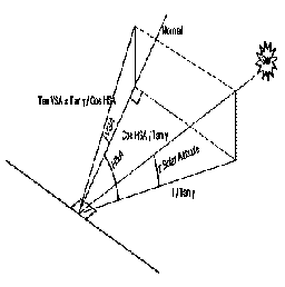 used
in design, namely plan and elevation. The angle between the direction of the
sun, resolved in the plane of the elevation, and the horizontal plane is known
as the vertical shadow angle (VSA). The angle between the direction of the sun,
resolved on the horizontal plane, and wall azimuth angle (the direction of the
normal to the surface projected onto the horizontal plane) is known as the horizontal
shadow angle (HSA). These relationships are illustrated in the diagram to the
right. The VSA in a given plane
is obtained from the projection of the line to the centre of the sun onto the
vertical plane containing the normal to that plane. The HSA is simply the angle
between the wall azimuth and the solar azimuth. The
VSA and HSA for a facade of given orientation may be calculated from simple
trigonometric considerations. Alternatively, they may be extracted graphically
from a vertical cylindrical solar chart using the appropriate overlay centered
on the direction of the required wall azimuth angle. This direction is defined
by the wall azimuth angle under study. The overlay used is shown below left
and is plotted to precisely the same vertical scale as the cylindrical chart.
It should be noted that the overlay is only 180° wide.
used
in design, namely plan and elevation. The angle between the direction of the
sun, resolved in the plane of the elevation, and the horizontal plane is known
as the vertical shadow angle (VSA). The angle between the direction of the sun,
resolved on the horizontal plane, and wall azimuth angle (the direction of the
normal to the surface projected onto the horizontal plane) is known as the horizontal
shadow angle (HSA). These relationships are illustrated in the diagram to the
right. The VSA in a given plane
is obtained from the projection of the line to the centre of the sun onto the
vertical plane containing the normal to that plane. The HSA is simply the angle
between the wall azimuth and the solar azimuth. The
VSA and HSA for a facade of given orientation may be calculated from simple
trigonometric considerations. Alternatively, they may be extracted graphically
from a vertical cylindrical solar chart using the appropriate overlay centered
on the direction of the required wall azimuth angle. This direction is defined
by the wall azimuth angle under study. The overlay used is shown below left
and is plotted to precisely the same vertical scale as the cylindrical chart.
It should be noted that the overlay is only 180° wide.
|
| 
|
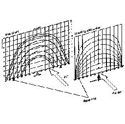
In this manner, the transparent overlay may be used to extract the VSA abd HSA from the solar charts for any orientation and latitude. The overlay is first oriented as illustrated in the diagram above right, so that it is aligned in the required direction. The date line under study is then identified on the solar chart and the hour lines intersections located. Dropping down vertically on the overlay for each point, the HSA can be read on the base line for that date and hour. The VSA can thenbe read off by interpolating between the plotted curved lines on the overlay, which represent the various VSA's. The HSA's and VSA's for any location have to be extracted separately for each facade orientation under consideration.
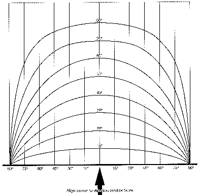
Many practitioners have a poor perception
of the movements of the sun when expressed in terms of the projections they
use for design. 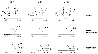 The
diagram to the right plots the VSA's for latitudes 35°N, 45°N and 55°N
on a north-south section. The
following points are evident:
The
diagram to the right plots the VSA's for latitudes 35°N, 45°N and 55°N
on a north-south section. The
following points are evident:
It is clear from the diagram, for example, that deciduous trees planted at acceptable distances to the south will have little impact on the direct beam insolation on a south facade at midsummer. The systematic extraction and graphical plotting of VSA's and HSA's for facade orientations under design consideration is highly recommended. This can be done in terms of simple angles in both plan and section.
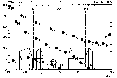
An example
Consider the plotting of a specific layout onto the solar chart overlay. The figure below left shows the layout under study. The HSA's are read off from the normal to the facade. As the obstructing buildings are parallel, it is only necessary to extract the VSA's for the ridge and two verges. It is adequate to record the VSA to the top of the tree. The outline can be transferred onto the overlay. The plotting of the parallel elements is achieved by using the VSA lines for guidance. These are lines of constant VSA. The plotting points have to be established first using the HSA's measured from the drawing. The resultant plot on the overlay is used with the vertical cylindrical solar charts. This overlay plot is shown below right:
|
Alternatively, it is possible to plot design graphs for any orientation expressed in terms of the VSA (y-axis) plotted against the HSA (x-axis) The figure below left provides an example. The sector width is 180°. The advantage of such a plot is that parallel obstructions plot as straight lines, as do horizontal shading overhangs of fixed width. Vertical obstructions plot as vertical lines. Thus, it is easier to perceive what is happening during design, working with orthogonal drawings. When using a cylindrical projection, there is a considerable shape distortion of typical building profiles like parallel roof lines and shading devices like horizontal overhangs, which makes design interpretation more difficult.
|
The figure above right shows the computer generated hourly sun positions plotted onto the VSA/HSA diagram for latitude 56°N for 22 December, 21 March/22 September and 21 June superimposed on the building and tree outlines of the plot directly above. It shows there is considerable winter sun obstruction due to the building on the left.
